Forespar's Point of View
Blogging About Life on the WaterTag Archives: navigation
What Do You Do If the Battery Quits?
So, you’re half way to the Island. It’s just after 10 pm, with no moon yet. It’s bumpy, and the visibility is poor. The 15 knot breeze is westerly, and the swell and wind waves are southwest. You know you’re getting pushed off course, but that’s OK, since both diesels are thumping away, and the GPS is telling where you are (and what to steer to get to the mooring).
Then, the instruments go dark. Yikes! Now what?
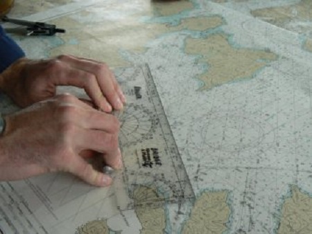
You have a compass mounted by the wheel. You whip out the Chart Book, grab your pencil and mark the last GPS position on the chart, then use your parallels to pencil a line to your destination. Then down to the compass rose, and determine a fair approximation of the compass course to the destination. Steer that course, and you’re good.
Oh, wait.
You don’t have charts, parallels, etc. And if you did, you don’t know how to use the low tech. You may just want to go real slow and listen for surf, and look for the red/green flashers at the harbor entrance. Not at all what you’ve planned, and not at all fun, even if it works out.
The kids, and grand-kids have asked “What are you doing?” when they see me using the hand-bearing compass for a quick sight at a point of land, make a line on the chart, and repeat the process in another direction. I’d explain that where those lines cross is where we are – on the chart, and then explain the cross bearing, and how I got it, and how simple it really is. Or, that same question when I scribble the time, course direction and speed when we’ve just cleared the harbor entrance, and an hour later walk over to the chart and draw a line, scribble some more, use the dividers, and draw an x. I give a quick explanation of dead reckoning, and how easy it is (and always a good idea on that dark night or foggy day).
The next question was always “Why do you do that if you have a GPS?” And answer always is “This will tell me where we are”. No, it’s not as accurate as the WAAS GPS and the Chart Plotter. But close enough if you’re talking to the Coast Guard (hope that doesn’t happen). It was good enough before the electronics, and basic navigation still works – inexpensive, quick and easy use and easy to learn.
What do YOU do if the battery quits?
Fog – MRASS Means Safer Navigation for ALL Boats
So here you are, searching for the point in the fog. No radar, and GPS these days can be a little iffy. You would rather not hit the reef off the point, or, the breakwater/jetty where the harbor is hidden behind that point. You’re blowing the your horn and/or ringing the bell as required. And going just fast enough to be able to dodge the usual idiot doing 20 knots when five is borderline.
And the foghorn on the point isn’t blowing. Because it’s fog-activated, and the sensors may be above the fog, and the system has never been particularly reliable. Hence, you and others who rely on that sound to determine the direction of a critical navigation point may wind up in a difficult situation.
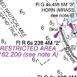
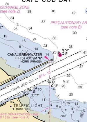
We now have the Mariner Radio Activated Sound System (MRASS). Many of the horns in foggy areas, such as New England, Great Lakes and the California Coast, have been updated with the new system, which allows boaters to activate the foghorns themselves using their VHF radios. You can read the Local Notices to Mariners online to see which local horns have been equipped.
The chart details shown below are examples of newer chart/GPS/Plotter updates, calling out the MRASS-equipped horns.
Go on your VHF radio (it is either channel 81A or 83A) and click the transmit key five times in a row. The horn will activate for 30 minutes. It works, and it can be real life saver. I’ve tried it outside Marina Del Rey, and it works.
Just another reason to love the Coasties.
Check for the Wreck
We’re continually surprised at what boaters don’t see when they’re charting a course or looking for an anchorage on the GPS or on a paper chart. You’d be surprised at the number of recreational skippers who think that fish bone symbol means it’s a fishing spot (often it is, but that’s a separate conversation).
What that really means is a shipwreck on the bottom. And, the form of the symbol is an indication of navigability – is it relatively safe to sail near or even over the wreck? Since boating safety is a paramount concern, this is something we all need know about sailing, and keeping the StaPlug, the raft and PDF dry.

On the left-hand chart, you’ll see two wreck symbols, and both are safe to sail across. The remains of the wreck are minimal, and they are in relatively deep water. However, you’ll want to be careful anchoring, as you could foul your and anchor or rode.
In the center, you’ll see the symbols with a dotted outline. That means STAY AWAY. Those wrecks are shallow enough to be a danger to your vessel. You’ll note that the lower wreck even has a notation “Mast”, meaning that the mast is above the surface at low water.
On the right is the symbol showing a semi-submerged hull on a reef. That one is self-explanatory – the wreck is at the surface, and is visible. Without knowing tide and current, the simple solution is to stay out around the 90-foot line. Since it’s not lighted, basic navigation applies (A cross bearing on the nearest lighted marks and a close check on the depth sounder).
Check the chart before you go in there, and plan/plot a course clear of the hazards. A little care will help you not be another symbol on the chart.
Mike Dwight